Monday, June 29, 2009

Grand Island to North Platte and Beyond in Nebraska

Readers may wonder why there continue to be pictures of rivers. Two reasons, rivers were important markers to the travelers going west and Alonzo always mentions them in his journal—even creeks get a mention—and it’s a way for me to document them as I travel west. I’ve been using Alonzo’s spelling of the Platt, but for the sake of Google searchers I’m going to switch to the accepted version, Platte.

(Double click on photos for a larger image)

Platte River at Grand Island, NE


Just west of Grand Island, south of the village of Alda, the Hall County Historical Society owns a two acre piece of land with wagon ruts that date to Brigham Young's first trek west in 1847. With the heavy rains and high grass this year you’ll have to use a little imagination to see them.


Hall Co. Historical Society Site


Murdick Site Wagon Ruts near Alda, NE


Prairie View on Hwy 30


August 5th Alonzo and his group camped on Elm Creek with the Mormons and made the necessary arrangements to join them, “ . . . for our safety and mutual protection and at this time I have the honor to be selected as Captain of our company. A great promotion indeed.” Alonzo was elected Captain to fit in with the Mormon train which was divided into groups of approximately ten people with a captain heading each of them.

Silas Richards, Captain of the Mormon train, wrote in his journal, “Sunday morning Augt, 5th, 1849. Morning fair. Our situation not being good for staying over Sunday (there being no timber), we traveled about 8 miles to Elm Creek & encamped at 12 O clock, day warm, flying clouds, south wind. Called a meeting of the camp in the evening to give some instruction relative to tieing cattle at night and other matters. The Cleveland O. company Capt. A W Rathbun with 13 other men joined our camp for safety in traveling. They travel with horses & carts.” 

"Camped on Elm Creek"


I camped in a motel at North Platte where the annual rodeo was in full swing.  The next morning as I left town I thought I was taking this westward trek entirely too seriously as I saw covered wagons coming down the road toward me.

On the Trail


The Old Fashioned Way


It was a tour group from Council Bluffs following the trail almost as it was done in the past, camping overnight along streams or rivers, and moving at the pace of a horse.

 Originally called the Nebraska, La Chata, or La Plat by the Indians, Spanish, and French—all of which mean shallow of flat—the Americans added the “te" to Plat. Alonzo often refers to it as the Nebraski or Platt. The river divides at North Platte and the Mormon trail turns  northwest near Ogallala, NE  following the North Platte River.

North Platte River at Buffalo Bill Park in North Platte


Driving across Nebraska one sees at least five or six enormous cattle feedlots. Perhaps many of the residents end their days in Ogallala.

Ogallala Livestock Lot


It’s here I leave Hwy 30 and follow the river up Hwy 26/92 which provides some lovely vistas toward the next stop at Ash Hollow.

"Don't fence me in"


Nebraska Scenes along Hwy 26

Sunday, June 28, 2009

Council Bluffs, IA to Grand Island, NE

Since crossing the Mississippi River the altitude has continually increased, and I was quite surprised at how much it had changed because you sense that you’re proceeding on an even keel. Granted you climb hills, but then you descend. See how the numbers increase as you move west: Burlington, IA, 502’; Ottumwa, 649’; Okaloosa, 841’; Council Bluffs, 984’; Grand Island, NE, 1862’.

 After crossing the Missouri River travel is mainly on Hwy 30 which meets the Platt River in Dodge County. On July 27th Alonzo wrote, “Drove 27 miles, dined at noon on the banks of the Nebraski or Platt River. It is a wide muddy steam at present very high, banks very low. Runs across the plains or prairie, looks beautiful to see such a body of water traveling across such an immense prairie. There are little patches of timber on either bank in places, cottonwood. It makes good coffee. We follow the north bank to Fort Larime some six hundred miles. Good road at present.”

 The next day they arrived at Loup Fork where the Loup River flows from the northwest into the Platt. I was unable to follow Alonzo’s trail along the Loup River as the road was closed due to a closed bridge at Columbus, NE. My first view of the Platt River occurred just south of Schuyler on the detour.

(Double click on photos for a larger image)

 Along the Platt River in Butler Co., NE


Alonzo followed the Loup River and on July 29th wrote, “Very wet for the plains this summer. Flowers of every hue and odorous.  Dined today on the banks of the Beaver River, coffee, corned beef, and hard bread for dinner. Encamped on the bank of Cedar Creek, a nice place. Passed through the old Pawnee village. The inhabitants are goen but if is the finest location in the territory.” Beaver Creek meets the Loup near Genoa and  Cedar Creek/River at Fullerton, both in Nance County. 2009 was also a very wet year on the plains, and every "local" that I spoke to commented that they couldn't remember the last time it was so green.

On July 30th they first sighted the Mormon train that he describes as, “ . . . wagons stretched on the plain as far as the eye could see. It was a fine panorama of real life to behold.”

On August 2nd, they had followed the Platt as far as Grand Island, NE, named La Grande Ile by early French Fur traders in the 1700s. It was an important landmark on the plains for pioneers. The Mormon, California, Oregon and Ox Bow Trails all went through this area as well as the Pony Express during its short life. The evening of my arrival I was greeted by a serious tornado warning with the funnel heading straight for Grand Island.

After the storm


The next day brought sunny skies and warm temperatures so I decided to visit the Stuhr Museum of the Prairie Pioneer and take a look around the city.

Stuhr Museum


A brave duck at the Stuhr Museum


Hall County Court House, Grand Island, NE

Thursday, June 25, 2009

The Bluffs at Council Bluffs

I inquired about the location of the bluffs because I wanted to see the view Alonzo would have seen 160 years ago. There isn’t one location for the bluffs as they run 200 miles from Sioux City, Iowa in the north to St Joseph, Missouri in the south.  They are up to 15 miles wide in some places. However, the only places they overlook the Missouri River are around Council Bluffs and at the northern end of the bluffs, near Sioux City. 

What makes the bluffs different than any other hills along a river? The bluffs consist of loess (pronounced like lust without the “t”); it's soil that is as fine as flour and formed by the wind into dunes. Since the prevailing wind is from the northwest, the dunes on the Iowa side of the river are the highest. Loess hills are found around the world, but only China has higher deposits than those in Iowa.

A popular high point on the bluffs looks over downtown Council Bluffs, the Missouri River, and Omaha in the distance. 

Above Council Bluffs


When the loess dunes are cut through for roads they display a tan surface without the color demarcations often found in regular soil or rock deposits.

Loess dunes


Alonzo notes, “Started on Monday (July 25) at noon for the plains and thence to the Salt Lake with one years provisions, rather poor road to the ferry. Encamped one mile from the ferry.

“Morning went to the ferry, crossed the Missouri at night. Encamped near the river in Indian territory. One Indian and two squaws encamped with us. They were Pawnees nearly naked and hungry.”

I also asked where the ferry might have been and learned that in the past the Missouri flooded every year so the ferries changed locations to fit the river. There were at least four ferries operating at any one time. The established location for the Mormon crossing is supposedly at the spot where I-680 crosses the Missouri north of the city. On my way to the Mormon Bridge I stopped at the Lewis and Clark overlook. In the center of the photo you can just make out the Missouri River (not the pond at the left), and at the right, near the horizon, are the runways of the Omaha airport.

North of Council Bluffs

Wednesday, June 24, 2009

Kanesville/Council Bluffs

Council Bluffs, originally Kanesville, on the east bank of the Missouri River, stands opposite the larger city of Omaha. The “civilized” and settled portion of the country ended at the Missouri. The Nebraska Territory began on its western shore. Other than a few trading posts there were few places to stock up on supplies. 

My day began at the Western Historic Trail Museum. An excellent facility that has interesting interactive displays about the Oregon, Mormon, and California trails. The entry drive crosses a large area of prairie.

(Double click on photos for a larger image)

Prairie at the Western Trails Historic Museum


Western Historic Trails Museum 


1852 map of the trails


Early Kanesville/Council Bluffs


Seekers of gold


When I asked about buildings from 1849 that still existed, the reply was yes, sort of. Alonzo would have seen the Kanesville Tabernacle where Brigham Young was confirmed as president of the Mormon Church. The 40-by-60 building is about two blocks from the original location and a detailed replica of the original. To create the authentic wooden surface volunteers distressed every plank that became part of the structure. The large fireplace is made of sod covered with mud. The fire would bake the mud and protect the underlying sod.

Tabernacle entrance


Brigham Young, center, in front of the Tabernacle


Sod fireplace


An antique wagon but not for the long haul


After the busy morning I was ready for lunch. I’d seen a large park when I came through downtown so I found Chinese take-out and headed for the park.


General Tso's chicken in the park


Bayliss Park, Council Bluffs


Alonzo wrote, “This evening I attended a dance in a log cabin, good times and good people.” My afternoon was spent driving up the bluffs--more about that tomorrow.

Tuesday, June 23, 2009

Oskaloosa to Council Bluffs

The day after Alonzo left Oskaloosa they broke an axel on one of their carts and had to make a new one.  The next day they broke the axel on another cart. The next town they stopped in was Chariton, Iowa. He describes the country between there and Mt. Pisgah as the most beautiful prairie that can be found in the United States. He writes that Mt. Pisgah was a Mormon Station with some 60 or 70 families and they spent three days there.

(double click on photos for a larger image)

Court House and band shell in Chariton, Iowa


Landscape between Chariton and Mt. Pisgah, Iowa


Monument for Mormon dead at Mt. Pisgah, Iowa


Road near Mt. Pisgah, Iowa

The next day they, “Drove 39 miles and stopped at Evans camp that was one family with thirty miles to the first neighbor and forty miles to the next.”  

It’s unclear if they continued west, in the area of what is now Hwy 34, until they were just south of Council Bluffs or if they followed the Mormon route from Mt. Pisgah up to Orient and then west on what is now Hwy 92. That’s the route I took.

Alonzo drove into Council Bluffs about four o’clock. I arrived about 6:00 p.m.

Sunday, June 21, 2009

Oskaloosa, Iowa

Dave Carr, one of the members of Alonzo’s company, had left the group at Burlington and gone down river; the plan was to meet again at Oskaloosa on the Des Moines River. Alonzo commented on the city, “Put up in Oskaloosa, rains very hard, quite a little place.” Since Oskaloosa wasn’t technically on the trail they were following, I was undecided about taking the detour north and then turning south again. When I checked the weather on Tuesday, June 16th it was overcast and had rained in the night. That and the fact that he did spend four days there, including the fourth of July, made my decision, and a fortunate decision it was. 

As I drove into town one of the first things that caught my eye was a town square with a lovely band shell so I found a parking spot, grabbed my camera, and headed for the center of the square. While working out the best angle for a photo, a gentleman passed by and I asked if he lived there. I wanted to know if this square had always been the town center. It seemed likely that the celebration on the 4th that Alonzo mentioned would have centered on the square. 

Band shell in the square and the current Court House


Not only was Randy Wright from Oskaloosa, he was a knowledgeable history buff involved in several interesting projects related to the city. After I explained my mission he invited me to his office just across the square where he had many, many photos of old Oskaloosa. He emailed me six of the earliest photos, all taken around the square and related to times around 1849, and you can see them below. The Court House in the first photo would have been there in 1849 when Alonzo and his company were in town. 
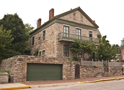
Court House under "E" and "r" in the photo title


Former Oskaloosa Court House restored


Young trees in the Town Square


Shops around the square


"Northeast corner of the square looking west"


Early Oskaloosa near the Town Square

Chief Mahaska on the square


Randy Wright and the Trail Monument


From Alonzo’s diary, “Morning yet in Oskaloosa waiting for Carr. Stage came in and no Carr. Meeting of the company was called this evening to take into consideration our situation by my greatest appeal to the company it was finally agreed to so that I accomplish my views. That is to dispose of our wagons for carts so that we could [accomplish] our journey with greater speed. The 4th all join in to pass the day merrily. A bower erected, an address delivered, marching through town, firing the anvil, etc. Some fine girls, some not so fine, some worse.” 

They started the next day with one four-horse wagon and eight carts, and crossed the Des Moines River at Farmers Ferry. I never could locate Farmer’s Ferry although I had an idea where it ought to be. Randy Wright consulted an old timer who knew the area well, and by the time I was an hour down the road he called on my cell phone with the answer.  It was near Tracy at Bellefountain, a little south of the location of the modern bridge on Hwy 92. 

Des Moines River west of Oskaloosa

Saturday, June 20, 2009

From Galesburg, Illinois to Ottumwa, Iowa

I suspect those of you following the blog have figured out that the postings are behind my actual journey. I'm posting for Monday, June 15th, on Saturday, June 20 from Nebraska. It isn't possible to post an entire day's travels plus download photos, and I suspect any readers would rather have brief, more frequent postings. At least I hope so. Also hope you'll be forgiving as I figure out the blog protocol.  I'm having a hard time thinking backwards as things have to be posted in reverse of how they happen. Can't tell you how many times I've had to delete because I got the cart before the horse.

On Monday, June 15th, headed out of Galesburg toward Monmouth following Alonzo's trail to Oquawka on the Mississippi River where a ferry was located. The winding road to Monmouth wound through beautiful rolling hills. The road to Oquawka, however, descended steeply to lower ground and then to bottomland, or as the residents referred to it, "the bottoms." Amazing how far inland the Mississippi has made its bed over the centuries.

Old-timers in Oquawka near the Mississippi River


Mississippi River at Oquawka, IL


Finished up in Oquawka and stopped at the county library in Biggsville for some help from two friendly librarians. Again descended from the rolling hills to the flood plain of the Mississippi to cross the bridge to Burlington, Iowa.

By 1849 some ferries on the river were large steamboats that could carry large quantities of cargo. Alonzo didn't describe the voyage except that it was six miles down the river to Burlington. At that point they, "Overhauled our load and weighed our baggage. Each man is allowed 75 pounds, mine weighs 65. We put on more provisions and I had a fine bathe in the Mississippi River."

Burlington is built on a bluff overlooking the river and the buildings crawl up the side of the hill. A beautiful new library was my first goal. Found some good information on Mississippi riverboats and ferries in their vertical files with excellent help from the librarian--just like home! Enjoyed an excellent lunch in the little library cafe before heading west and looking for the Agency Road.

Bridge across the Mississippi from the Burlington Library


Street in Burlington


After the Black Hawk War, the Sac and Fox Indians were moved west because of the 1837 treaty. There were about 2300 Indians set up in six villages just east of Ottumwa in what is now called Agency. The Agency Road led out of Burlington to Lowell on the Skunk River where Alonzo's party crossed on a ferry. Their lock chains broke so they camped there for the night as they repaired their equipment. By 1849 the Skunk River had already been dammed for water power.

Hillsboro, formerly Washington, was on a route that can no longer be followed today. Pieces of the Agency Road exist in places, but it took some doing to get to Agency on the back roads and still trying to follow the trail as closely as possible. I took my overnight in a Super 8 in Ottumwa instead of camping on the Skunk River. No surprise to those who know me.

Hillsboro Public Library


Ottumwa, another city climbing a hill with a river below, the Des Moines; a high hill on the north side and flat land on the south. Also a city, like Galesburg, that appears to have escaped urban renewal as it has some nice early public buildings. The older streets are heavily shaded with overhanging trees and it reminded me of the way Grand Rapids looked before it lost all its elms. Next time I'll follow the trail to Oskaloosa, which I almost didn't take--what a loss that would have been. Tune in for the next episode.

Ottumwa, IA